Friday, April 29, 2016

Hiking in North Central Idaho


Hiking is one of the best ways to get outside. It might seem like it’s just walking, but actually there’s a little more to it. Before you go out on a hike, it’s important to be prepared.

The first thing you need to do, of course, is decide where you’re going.  You should get a map of the trail.  This is really helpful because it tells you how far you will go, and if the trail branches, it can tell you which way you should go.  Another great thing about having a map is that you can use it to know exactly where you are on the trail, just in case there’s an emergency.


There are a lot of great sights to see while you're hiking
Speaking of emergencies, you should always tell someone where you’re going and when you plan to be back.  You also want to make sure you have the right gear.  This would be appropriate hiking shoes or boots and appropriate clothing (including some extra clothes, just in case it’s colder than you expect or something happens to the clothes you’re wearing – I once slid down a muddy hillside and didn’t have any extra clothes, which kind of ruined the rest of the day).  You’ll also want to bring food and water, a first aid kit, a compass along with your map (if you’re in the woods, a GPS might not always work), a flashlight, a whistle, and a knife or some other similar tool.  There are some more suggestions, as well as reasons why these ones are important, at http://www.americanhiking.org/resources/10essentials/.


Don't forget to take pictures!
Most of the time, you’ll be fine and won’t run into any problems. Even on these hikes, though, it is important to have these things along.

You’ll also want to brush up on your hiking etiquette before you head out on the trail.  It’s pretty simple.  Basically, don’t be too loud and don’t block the trail.  If you need a rest, pick a spot where you can get off the trail so that others can get past you.  One of the most important things to me is: don’t litter.  When people are hiking, the last thing they want to see is your plastic bottles and wrappers.  Besides that, you never want to throw away something that can hold water, especially if you’re going on a long hike.  You might run out of the water you brought and have to purify some more, but that won’t help you if you don’t have anything to carry it in.  The website, http://www.americanhiking.org/resources/hiking-etiquette/, has more etiquette standards that you might want to check out.
Hiking is a fantastic pastime, and I highly recommend it.  You just need to be aware and be responsible.

Thursday, April 21, 2016

Adventures on Horseback


There are many specific spots in North Central Idaho that are great to visit. Sometimes, though, it’s nice to go see the places that don’t have names. There are several ways to do this, but one of my favorites is on horseback.
Part of why I love to explore on horseback is because I love horses. Another reason is because, as you might have noticed, I love local history. Horses are an important part of local history. Appaloosas were bred by the Nez Perce in this area, which changed the lives of these people. Horses also brought the settlers here and helped them work their farms and get from one place to another.
Another great reason to explore is because riding a horse is faster than walking and horses have greater endurance than people do. This means that you can see more, go farther, and stay out longer than you would if you were hiking.

You can also ride horses just about anywhere. Of course, if you go on private property, you need to ask for permission. However, there really isn’t any need to go on private property. You can ride in most Idaho state parks and national forests. You can even ride alongside the road, although you might want to take some safety precautions, such as wearing clothes that are easily visible.
Finally, even if you don’t have a horse or have never ridden before, there are a number of ranches where you can rent horses and tack and have a guide come with you. These trips will probably be on the ranch’s property, and you’ll get to see places that you wouldn’t be able to see from the road or that the owner of the property wouldn’t let you go on foot.
For your next adventure in North Central Idaho, you just might want to consider taking a horseback ride.

Saturday, April 16, 2016

Winchester Lake


North Central Idaho isn’t all mountains and rivers – we also have a few small lakes. Probably the most popular of these is Winchester Lake, which has the town of Winchester practically right on its shores.  The lake is 103 acres and is surrounded by trees.
No matter what outdoors activity you like best, you can probably do it at Winchester Lake.  Of course, there is the obvious fishing.  In addition to regular fishing, the lake is also a popular spot for ice fishing.  In fact, if the ice is good enough, they hold an ice fishing derby each year at the end of January.
Boating is also, naturally, an option here.  Only small, electric motor boats, canoes, kayaks, and other small boats that require physical work are allowed, though.  Canoes, along with paddles and life jackets, are available to rent for a reasonable cost.

Additionally, there is a fantastic campground here.  They’re open from Memorial Day to Labor Day.  Besides that, there are also year-round yurts that you can rent.
If water isn’t so much your thing and you’d rather stay on land, there are some beautiful hiking and biking trails around the lake.  If you don’t own a bike or just don’t want to have to haul one out to the lake, you can rent one.  In the winter, these trails are great for snowshoeing.
Whether you want to go for an overnight camping trip or a day trip, Winchester Lake is a great choice!

Friday, April 8, 2016

The Corps of Discovery in Idaho


Many of the mountains the Corps of Discovery had to cross
are taller than these.
You can’t go very long in North Central Idaho without coming across a reference to the Lewis and Clark expedition, also known as the Corps of Discovery.  Lewis County is named after Captain Meriwether Lewis, as is the town of Lewiston.  Just across the Snake River from Lewiston is its sister-city, Clarkston, Washington, named after Captain William Clark.  Lewis-Clark State College is jointly named after both of them, and throughout the area, you find historical sites related to their journey.


The explorers traveled through the region in 1805 on their way to the Pacific Ocean, becoming the first Americans to explore the area.  They passed through in 1806 on their return trip, following approximately the same route as they did the first time.


The Corps of Discovery had to travel rivers like this
They entered Idaho through Lolo Pass.  Before that, they set up a camp that Lewis dubbed “Traveler’s Rest.”  Today, Traveler’s Rest is a Montana state park.


The journey through Idaho was not easy between the mountains, rivers with rapids, and heavy September snow falls.  Today, though, these obstacles post little trouble to travelers and are much of what makes Idaho so beautiful. One way you can enjoy them is by retracing the Corps of Discovery's journey along US Highway 12, which parallels their travels fairly well.  You can even buy interpretive CD’s to listen to as you drive and learn about what happened in the places you are passing.

As you follow this route, you’ll find a lot of brown historical site signs designating a point of interest.  Most of these spots don’t have an interpretive center or anything like that, but it is still fascinating to be there and think about what happened.  If you want to take a road trip in Idaho, I can’t recommend a better one than following the journey of the Corps of Discovery!

Friday, March 25, 2016

The Rivers of North Central Idaho


The Salmon River outside Whitebird
Idaho is famous for its scenery. There are mountains, forests, rivers, and fields. There are four main rivers in North Central Idaho: the Snake, the Salmon, the Palouse, and the Clearwater.  The Clearwater is the result of the convergence of three different rivers: the Middle Fork, the Lochsa, and the Selway.

These rivers are a big part of what makes North Central Idaho so beautiful.  They also have historical significance and they provide a number of great activities to do outdoors.


The Snake River near Buffalo Eddy
In 1805-1806, Lewis and Clark passed through North Central Idaho on their journey across the American wilderness.  The rivers played an important part in the journey, as the explorers used canoes to travel down the Clearwater and Snake Rivers on their way to the ocean.

The Clearwater and its tributaries the Lochsa and the Selway, as well as the Salmon, are very popular for their whitewater rafting.  Jet boat rides on the Snake River, which runs through Hells Canyon, has also become quite popular, with a number of companies offering rides and guides.


The Clearwater River in the Clearwater National Forest
If you’re looking for something a little calmer, there are a number of small beaches along these rivers.  Two of the best are Three Devils on the Clearwater and Skookumchuck on the Salmon.  There are also picnic tables at these and many of the other beaches.  A word of warning, though – if you decide to go swimming, the currents and undertows in the rivers can be tricky and dangerous.  Be very careful.
Miles and miles of highway lie along these rivers, much of it also passing through forests.  If you just want a scenic drive, you need look no further than the rivers of North Central Idaho.


Friday, March 18, 2016

Buffalo Eddy

Buffalo Eddy is the name of a section of the Snake River where the river takes several sharp turns.  However, the most fascinating part of the area is not the river: it is the collection of petroglyphs found on either side of the river. These petroglyphs were left there perhaps even 4500 years ago by the Nez Perce.
The petroglyphs show a number of different kinds of pictures.  Some are of people or animals, while others are more abstract. According to a sign at the site, we don’t know for certain why the petroglyphs were carved.  Probably, as the sign suggests, the site held some spiritual significance.

As the National Parks page about the site tells us, the petroglyphs are dated by looking at what the subject matter is. Just like we know that a painting from Western society containing a car or train could not have been made before the invention of those vehicles, we can tell that petroglyphs containing images of inventions that the Native Americans created could not have been made before those things were used.
There are also a few pictographs on the site. Pictographs are paintings or drawings, as opposed to petroglyphs, which are carvings. The pictographs can be dated using chemistry, by analyzing the pigments used in them, as the National Parks page once again tells us.
This is one site that you’ll have to leave North Central Idaho and go into Washington to see. There are petroglyphs on the Idaho side of the river, but this side is closed to the public. The Washington side, however, is not far from Asotin and is right by the highway.
Buffalo Eddy is one of the sites that make up the Nez Perce National Historical Park.  Some of the other sites include the Heart of the Monster and the Whitebird Battlefield, which I have also written posts about.


Thursday, March 10, 2016

The Whitebird Battlefield


The Whitebird Battlefield
For someone as interested in local history as I am, the Whitebird Battlefield makes an excellent place to hike.  It is the site where, on June 17, 1877, Captain David Perry of the U.S. Cavalry led a little over a hundred men against a group that is estimated to have been anywhere from 50 to 140 Nez Perce warriors.


Today, the battlefield is a pretty desolate-looking place. A walking trail of about one and a half miles stretches through it. There are six stops along this trail where visitors can learn more about the events of the battle.


It would have been hard to get around in the midst of a battle
Desolate or not, it is still an intriguing place. When I was probably five or six, I went there on a field trip. We had a guide who was able to describe where and when the events of the battle took place. Ever since then, it has been one of those places where history doesn’t seem very far away for me.


If you decide to visit for yourself, you need to remember that the area gets very hot in the summer. You’ll need to bring water and sunscreen and be sure you’re dressed appropriately.


If you want a bird’s eye view of the battlefield, there is an overlook above it on Highway 95.


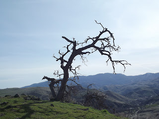
This snag grows on the top of a hill in the middle of the battlefield
The Whitebird Battlefield is one of the sites that make up the Nez Perce National Historic Park. Another site is The Heart of the Monster, which I also have a blog post about here.

Saturday, March 5, 2016

The Heart of the Monster


The Heart of the Monster from the beginning of the walking trail
            Just outside of Kamiah along the Clearwater River lies a huge mound.  The Nez Perce who live in the area call it “The Heart of the Monster”.

            They have an ancient legend about it, which is their creation story.  In the story, Coyote – who is a hero in a number of Nez Perce legends – saves the animals from a terrifying monster who is eating them all.  You can hear the whole story at a kiosk on the site.


The Heart of the Monster
            The Heart of the Monster is right beside Highway 12 and is only a couple of miles outside of Kamiah.  There is a very short walking trail that allows you to get close to the Heart.  The kiosk allowing you to listen to the whole story is located at the end of this trail.

            There is also an overlook with a shelter that allows you to get a good view of the Heart. You can also listen to the story in Nimiipuu here, or read it in English from the walls.

            If you want a little bit more of a walk than the park allows, you can also go just across the Clearwater River to the Riverfront Park just on the edge of Kamiah and walk along the river bank.

            The Heart of the Monster is just one of 38 sites that make up the Nez Perce National Historical Park, with sites located in Idaho, Washington, Oregon, and Montana.
            If you’re looking for a short walk with a mix of history and mythology, then this is the place for you!
 

Thursday, February 25, 2016

The Railroad on Stilts

Halfmoon Trestle above Highway 95
            What on earth is the Railroad on Stilts?  This is the nickname of the Camas Prairie Railroad, which ran through a number of towns on the Camas Prairie of Idaho.  Although the railroad is no longer used and has fallen into disrepair – in fact, the tracks have been pulled up in several stretches – it is still very visible throughout the Prairie.

            According to a 1938 edition of The Lewiston Morning Tribune, the railroad was built in 1908 in order to settle an argument between the Northern Pacific Railroad and the Union Pacific Railroad over which one should control the Camas Prairie.  The first train ran on December 7, 1938.

            The railroad was a major source of transportation in the area for both passengers and goods.  However, by the early 2000’s, the railroad was largely abandoned, and several sections of tracks were pulled up, as American-Rails.com reports.
One of several tunnels along the railroad
            Even so, many of the tracks remain, as do the several tunnels that the trains would pass through as they made their way from Grangeville to Lewiston or back again.  Most of these tunnels are short, but there is one that makes a full ninety-degree turn and is pitch-black in the middle. This one is located right above Highway 95 in the canyon between Winchester and Culdesac.
The steel viaduct in Lawyer's Canyon
            The most impressive part of this railroad, though, is what earned it the nickname of the Railroad on Stilts: its trestles.  As the railroad wends its way through canyons and the relatively flat portions of the Camas Prairie, it crosses numerous wooden trestles. There is even a steel viaduct in Lawyer’s Canyon that is 1520 feet long and 280 feet high at its highest point.
            The railroad is a great place to visit. It runs through Grangeville, Cottonwood, Ferdinand, Craigmont, Reubens, and Lapwai, connecting to Lewiston.  You can easily see trestles from several of these towns, especially Cottonwood, which has a large trestle within city limits.  There are also many trestles visible from Highway 95 between Winchester and Culdesac.

            If you’re up for an adventure, you can see even more of them hiking.  I should give you a word of caution, though.  Hiking always involves some risks, and there are even more on railroad tracks.

            The tracks themselves are unevenly spaced and can be difficult to walk on.  If you cross any trestles, be extra careful because it’s a long drop from the top of them.  Tunnels can be dark and have falling rocks.  Finally, you definitely want to check to make sure you’re not going on private property.  If you are, you must get permission from the owner.

            Even if you don’t actually want to go out and see the railroad up close and personal, there is a way to enjoy it straight from your living room.  The 1975 movie, Breakheart Pass starring Charles Bronson, was filmed on the railroad.  It’s a lot of fun to see the familiar background featured on screen!

Thursday, February 18, 2016

North Central Idaho

 
Where is North Central Idaho?


Idaho is shaped so that the northern half of the state is much narrower from east to west than the southern half. Even so, this northern area – called the Panhandle – is still a big area. In fact, it contains ten counties. Because of this, the Panhandle is divided into North Idaho and North Central Idaho, with five counties in each region. At approximately 600,000 acres, North Central Idaho is still a pretty big section of the state.


A snag of a tree at the Whitebird Battlefield


What do you do in North Central Idaho?

A tunnel along the Camas Prairie Railroad

If you like the adventures in the great outdoors, this is the place for you! Whether you like hiking, horseback riding, rafting, fishing, biking, skiing or snowboarding, camping, and taking a scenic drive, North Central Idaho has it all.

There is both natural beauty and fascinating history to be experienced in this region. Mountains, rivers, and forests are never far away here. Along with parts of Oregon and Washington, it is home to Hells Canyon, the deepest canyon in North America. It also boasts of Dworshak Dam, the tallest straight axis gravity dam in the Western Hemisphere.


An abandoned barn near Nezperce, ID

Besides setting some impressive records, there is a great deal of history to be found in North Central Idaho. There are many Native American cultural sites throughout the region. The Lewis and Clark Trail goes right through the area. Old homesteads and one-room schoolhouses dot the countryside. Battlefields from the Nez Perce War remain.


There are plenty of things to see and do in the great outdoors of North Central Idaho! In the upcoming weeks, I'll be highlighting some of the different places to see.